Thomas Tunaley Snr.'s Ownership of Premises on "The Holmes", Derby, prior to 1809. |
||
|
Derby Mercury, 28 June, 1809(this information courtesy of Dr. Jane Holems, Auckland)
“TO BE SOLD BY AUCTION, BY Mr. SHAW At the house of Mr. Slater, the Dusty Miller, on Cockpit Hill, Derby, on Saturday the 8th day of July, 1809, at 5 o’ clock in the afternoon, subject to such conditions of sale as will then be produced: A LEASEHOLD BUILDING under the Corporation of Derby, now occupied by Mr. Slater and James Pipes and A FREEHOLD PROPERTY adjoining the Leasehold Estate, lately occupied by Mr. Tunaley, dyer. Particulars in next Week’s Paper; and of Mr. Shaw, Derby. N.B. The above premises may at an easy expense be converted into Warehouses, being very advantageously situated near the Canal Wharfs. “
Click here or on image to enlarge
N.B. In this context, the definition of "Holm" or "Holme" is a piece of flat land lying next to a river.
In fact "The Holmes" is an area in Derby part of which was later owned by Michael Bass, http://spartacus- educational.com/PRbass.htm owner of the famous Bass brewery. Bass subsequently donated this land to the Derby Corporation and the area became better known as Bass’s Recreation Ground.
In the advertisement, there is mention of Cockpit Hill where the auction took place at the Dusty Miller, a wharf, warehouses and of course "lately occupied by Mr. Tunaley, dyer". In fact the only wharf in the immediate area was Gandy's wharf alongside the Derby Canal as shown in the figure. Warehouses would have stood close to the wharf and the ad. indicates the leasehold part of the sale could be used for further warehousing. The Derby Mercury notice contains no mention of a mill so it's concluded the Tunaleys were already operating as dyers before the move took place to Tenant Street. An approximate time for the move to Tenant Street is implied in the words "lately occupied" so it's reasonably assumed this was earlier in the year 1809 or 1808 at the earliest. The move to Tenant Street was a particularly astute one because the Tenant Street dyeing house lay adjacent to the Strutts' cotton, calico and silk mill that stretched from the Cornmarket almost to the Morledge. This enterprise headed by Jedediah Strutt's youngest son, the philanthropist Joseph Strutt. What is not known for certain is when the Tunaleys purchased the premises on "The Holmes". However, circumstantial evidence strongly indicates this purchase to have taken place in the 1780's. For details on the move from silk throwing to dyeing and the reasons this took place go to Hall and Tunaley-Silk Throwsters
More on the Derby Canal
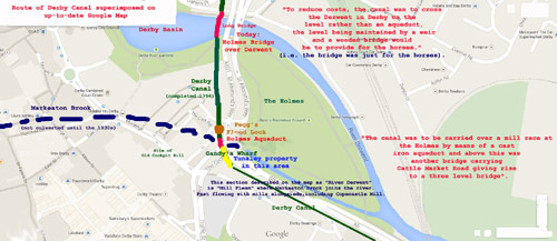
Derby as it is today. The 44ft. Holmes aqueduct actually went over Markeaton Brook which in 1796 would have been unculverted. The bridge over the Derwent was for the horses that pulled the boats over the river, the river kept at a level height by means of a weir. Today, the weir is still very much a feature of the Derwent at that location. As such, the "Long Bridge" was not an aqueduct as might be implied by some documents that have been read. Today's road bridge over the Derwent is still called the Holmes Bridge.
as a "mill race" so one can be fairly confident that the corn mills were located at the side of the "fleam" including Copecastle mill. The main engineer for the Derby Canal was the Derbyshire civil engineer Benjamin Outram who designed and built, using his own company, the 44 ft. span cast-iron Holmes Aqueduct over the Markeaton Brook. The Holmes Aqueduct was completed one month ahead of Thomas Telford's longer aquduct on the Shrewsbury Canal. Castlefields area. According to documents, Copecastle Mill and Castlefields reflects the belief there was once a castle in that area. Likewise Cock Pit Hill suggests there was once cock fighting at that location although it's pleasing to note that no such evidence has yet been found. One item of minor interest is that the road system where Cock Pit Hill was formerly located is now called the Cock Pitt with an associated Cock Pitt Island. No doubt this is because "Pitt" was the correct spelling in the seventeenth century when the "Cock Pitt" was first mentioned in records.
N.B. Since the above was written, Paul Tunaley has submitted a copy of an 1846 Henry Burn lithograph of Derby taken from the Meadows area of Derby. This gives a panoramic view of Derby from Cockpit Hill and across The Holmes and Markeaton Brook round to St. Alkmund's Church and the Derwent river. This view confirms the geographic details given above. For further information, contact the author, Phil Tunaley, at: phtunaley@live.com
Click here to go back to Thomas Tunaley Snr. web page
|
|

The Tunaley Family History
Click on Names to Navigate the Tree